Comments
Popuppete t1_j6u50gs wrote
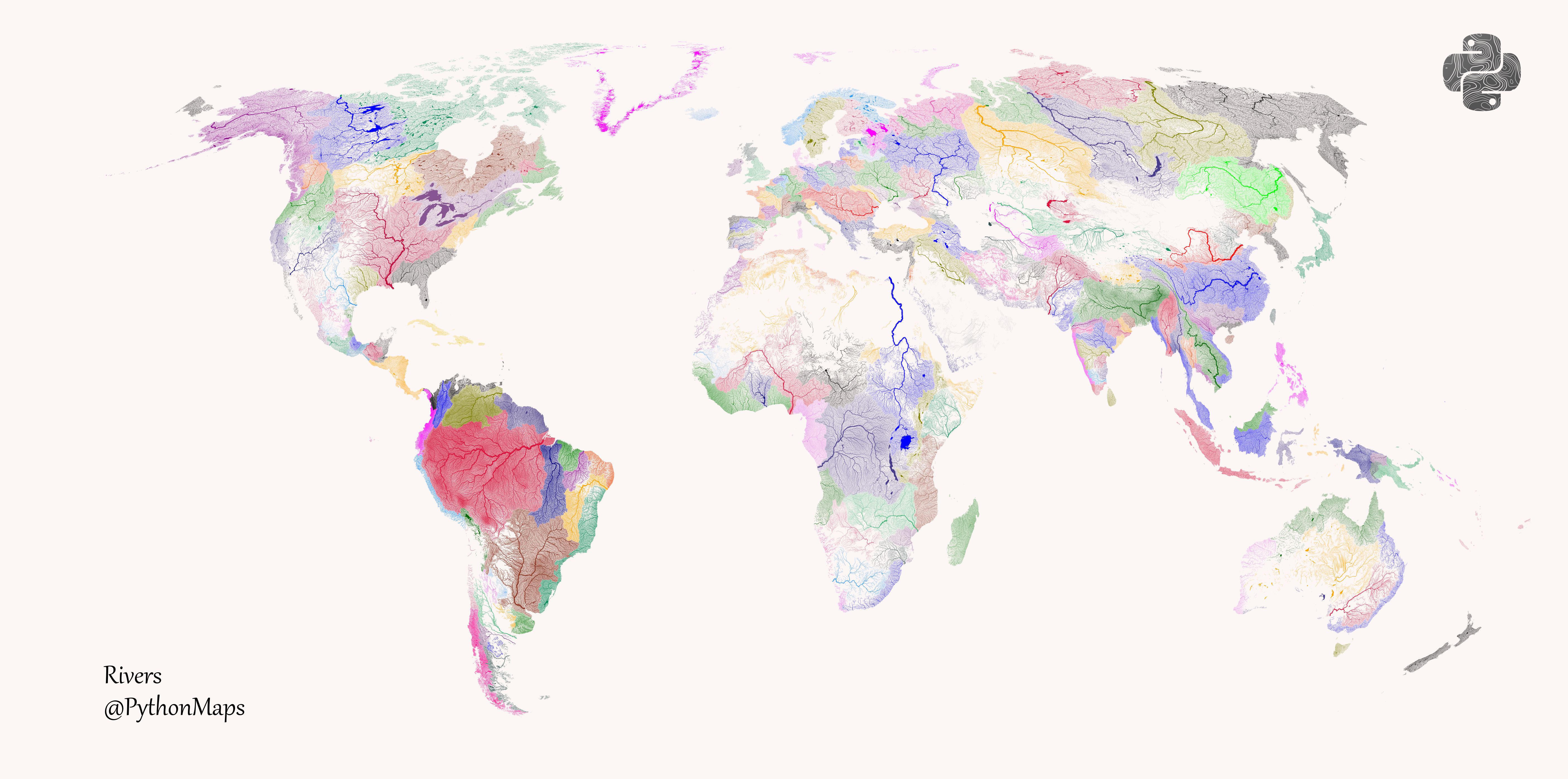
Yeh, it seems way too small. When you see how fast the Niagara River flows and also the St Laurence. I just don’t get how there is enough rain to supply the outflow.
atx_californian t1_j6uni81 wrote
There is a gigantic bedrock bowl beneath the great lakes that traps anything that falls on it. There isn't really anywhere for the water to go other than towards Niagara falls. Other basins probably have more groundwater absorption by comparison
lurker_101 t1_j6wm9td wrote
What we are looking at is the veins and arteries of the world .. and the sky is the heart pulsing with the Sun
.. eventually the Earth will have a heart attack
tirikai t1_j6ssyjg wrote
Technically NZ is on this map, but it was kind of left off this map
RudionRaskolnikov t1_j6tbft5 wrote
Amazon river basin is beefed as fuck
JulianLoop t1_j6t4wrl wrote
Great map :) but personally i would like it more, if Oceans and big lakes would be in a light color, so you don’t mix them up with areas where no rivers are
Old_AP_Pro t1_j6t8sy7 wrote
According to this map all the rivers in England have the same basin. I don't think so.
Tracorre t1_j6ug6kk wrote
A lot of coastal areas are like this, where because they are near the coast there isn't the opportunity for rivers to really group into a singular basin, it is just an area where many many different rivers go into the sea and each individual river basin would be very small. Some sort of grouping is happening in areas like that.
Old_AP_Pro t1_j6umw5y wrote
There are 10 river basin districts in England.
Anglian, Dee, Humber, North West, Northumbria , Severn, Solway Tweed, South East, South West, Thames
Therefore, England should have ten colors, not one as shown on this map.
Tracorre t1_j6uq263 wrote
Well yes, but if it did that it would be creating very small river basins all along various coastal areas. All of the US coasts have this same issue, and much of the African coasts and SouthEast Asia, etc. There is a grouping compromise being done somewhere to prevent having so many small basins. A map of this type of just one country could split them up, but whole world would be just too busy.
Old_AP_Pro t1_j6w3jyq wrote
Italy is split ip to east and west coast. Roughly the same size as England, and smaller than England, Scotland, Wales combined.
Greenland, Sweden, Norway also wrong.
[deleted] t1_j6we9pz wrote
[deleted]
Old_AP_Pro t1_j6uqpdh wrote
There is no way All of the rivers in England belong to the same hydrological basins. The Thames, east coast is very distinct to the Severn, west coast.
itsalilbitlit t1_j6v6bqz wrote
You obviously did not comprehend the comment you responded to...
[deleted] t1_j6v9dot wrote
[removed]
TruestRepairman27 t1_j6thul9 wrote
Pretty sure not every river in Alaska is the same drainage basin
Foxs-In-A-Trenchcoat t1_j6t14n7 wrote
Updoot for hydrological basins
thearchiguy t1_j6tl2k9 wrote
The ones for the continents look great and maybe accurate but the ones for island nations look off and should've been of different colors. The one I'm knowledgeable of - for the Philippines, I can tell you that just the northern main island (Luzon), there should be different systems and not all of them are of the same drainage area. The map makes it look like all the rivers in an island are all connected to one another.
Boatster_McBoat t1_j6v3hqx wrote
Australia is weird af as well. Eastern seaboard is treated as one basin which is bizarre
symmy546 OP t1_j6squ58 wrote
Feel free to follow the PythonMaps project on twitter - https://twitter.com/PythonMaps
The map was generated with matplotlib, numpy and geopandas.
Data comes from https://www.hydrosheds.org/ and K. Andreadis, G. Schumann, and T. Pavelsky, A simple global river bankfull width and depth database, Water Resour.Res., in review.
FudDeWhack t1_j6u0h3k wrote
Super interesting and beautiful indeed! Thanks for sharing! Is there maybe a version with the rivers' names on it?
vozv t1_j6tsn8s wrote
There is something wrong I think with certain rivers, it feels like they are colored based on which country they’re in and not where they flow to? Super beautiful map though, starred at it for a really long time.
Boatster_McBoat t1_j6v3dau wrote
Interesting definition of basin that incorporates almost the entire eastern seaboard of Australia but only extends inland at most a few hundred kilometres.
Must be 30 major rivers that independently reach the ocean across this expanse let alone hundreds of smaller ones
tangcameo t1_j6vbfew wrote
There’s a creek in Saskatchewan that if you follow it downstream you end up in the Gulf of Mexico. Although you’ll need an extremely tiny boat at the start.
FlurpZurp t1_j6vuqe8 wrote
“Rivers of the World, Unite!”
- The Ocean, probably
[deleted] t1_j6t14mb wrote
[removed]
DBL_NDRSCR t1_j6uawo4 wrote
ugh please divide it more and make a bigger image, looks good tho
[deleted] t1_j6ucy4h wrote
[removed]
[deleted] t1_j6uibtn wrote
[removed]
AlexTheDataExplorer t1_j6uxdnk wrote
would be helpful to have a key labeling the basins
[deleted] t1_j6v4poc wrote
[removed]
druffischnuffi t1_j6w60ce wrote
I live close to the divide between Rhine and Danube (green and red). It is amazing how the Rhine flows in a semicircle around the Danube basin.
It gets really weird since a part of the Danube water sinks into the ground, crosses the divide through cracks in the earth and later enters the Rhine. https://en.wikipedia.org/wiki/Danube_Sinkhole
mcnuggetfarmer t1_j6w86j3 wrote
How does the inland one in South Africa, between the blue and green, not run into a coastline? Where is it going
Jurassic_tsaoC t1_j6wefs6 wrote
The Okavango ends in an inland delta.
GeorgeofJungleton t1_j6wq44e wrote
It's actually pretty cool, there's a vast inland delta where the average annual evaporation is ~equal to the average annual inflow. The water pools in a vast area of brackish swamp and lagoons which swell in the wet season and reduce in the dry.
ColinTheMonster t1_j6xp9my wrote
I wonder how these align with cultural groups. Places like the UK, Canada, and Scandinavia seem to have drainage basins that align with different cultural regions of the countries (probably because their borders align with mountain ranges).
Grason20 t1_j6zfa5e wrote
Nile is so clear to see here.
yellow_edge t1_j6svemf wrote
I'm always amazed at how close you can get to the Great Lakes and have water flow away from them.